In the age of advanced technology, the capabilities of satellites seem almost limitless. From providing internet access to monitoring weather patterns, satellites play a crucial role in various aspects of our daily lives.
But can they read license plates? This question often arises due to the fascination with satellite technology and its potential applications in surveillance and monitoring.
In this article, we’ll delve into this intriguing topic, exploring the feasibility, limitations, and implications of using satellites to read license plates.
Understanding Satellite Imaging Technology
Satellites are equipped with sophisticated imaging systems that capture high-resolution images of the Earth’s surface from space. These imaging systems typically fall into two categories:
Optical Imaging
Optical imaging satellites use sensors to capture visible light, allowing them to create detailed images of the Earth’s surface. These images are often used for various purposes, including urban planning, agriculture monitoring, and environmental assessment.
Synthetic Aperture Radar (SAR)
SAR satellites use microwave signals to penetrate clouds and darkness, enabling them to capture images regardless of weather conditions or time of day. SAR technology is particularly useful for mapping terrain, monitoring changes in land cover, and detecting objects on the Earth’s surface.
The Feasibility of Reading License Plates

While satellites can capture detailed images of the Earth’s surface, the ability to read license plates from space poses several challenges:
Resolution
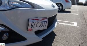
License plates are relatively small compared to the vast expanse of the Earth’s surface. To read a license plate from space, a satellite would need exceptionally high resolution to capture clear and detailed images of the plate.
Distance
Satellites orbit the Earth at altitudes ranging from a few hundred kilometers to thousands of kilometers. At such distances, capturing clear images of small objects like license plates becomes increasingly difficult due to atmospheric interference and the curvature of the Earth.
Motion Blur
Satellites move rapidly relative to the Earth’s surface, making it challenging to capture sharp images of moving objects such as vehicles. Motion blur can further degrade the clarity of license plate images captured from space.
The Role of Image Processing
| Image Processing Technique | Description |
| Image Enhancement | Improves the quality of satellite images for better clarity |
| Pattern Recognition | Identifies and extracts specific patterns or objects |
| Machine Learning Algorithms | Automates the process of analyzing and interpreting images |
| Optical Character Recognition (OCR) | Converts text in images to machine-readable format |
| Noise Reduction | Minimizes unwanted artifacts or distortions in images |
Image processing techniques play a crucial role in extracting valuable information from satellite imagery, enabling tasks such as object recognition and text extraction for various applications.
They aid in addressing challenges like determining whether a bike rack can cover your license plate in an image.
Limitations and Ethical Considerations

While it may be technically feasible to read license plates from space under ideal conditions, several limitations and ethical considerations must be addressed:
Privacy Concerns
The ability to read license plates from space raises significant privacy concerns. Individuals may feel uneasy knowing that their movements and activities can be monitored from orbiting satellites.
Legal Restrictions
In many jurisdictions, the use of satellite imagery for surveillance purposes is subject to legal restrictions. Unauthorized use of satellite imagery to gather information about individuals or vehicles may violate privacy laws.
Accuracy and Reliability
Despite advancements in technology, the accuracy and reliability of license plate recognition from satellite images may vary depending on factors such as image quality, lighting conditions, and vehicle speed.
FAQ’s
Can satellites capture clear images of license plates from space?
Satellites can capture detailed images, but reading license plates from space presents challenges due to distance and resolution limitations.
What factors affect the readability of license plates from satellite images?
Factors such as satellite altitude, atmospheric conditions, and vehicle speed can impact the clarity and readability of license plates in satellite images.
What are the privacy implications of reading license plates from space?
Reading license plates from space raises significant privacy concerns, as it enables monitoring and tracking of individuals’ movements on a large scale.
Conclusion
Satellites possess remarkable capabilities for capturing high-resolution images of the Earth’s surface. The feasibility of reading license plates from space remains a subject of debate.
While technically possible under ideal conditions, several challenges and limitations must be addressed. These include resolution, distance, motion blur, and ethical considerations regarding privacy and legal restrictions.
Technology continues to advance. It’s essential to balance the potential benefits of satellite imagery with the need to safeguard individual privacy and civil liberties.